VPS

Enterprises don’t operate in demo labs. Instead, they capture spaces with various tools such as LiDAR carts, drone photogrammetry, 360° cameras, and even iPhones. Often, they rely on multiple techniques within the same facility. A “best AR VPS platform” must effectively digest any scan, localize across several floors, and update only the changing zones. MultiSet AI’s VPS was engineered specifically for this purpose.
LiDAR measures geometry directly and does not care about light. Point it down a dark pipe rack at midnight and it returns the same distances it returned at noon. What it does not read is meaning. Every surface is a surface, and a long corridor of identical racking looks to a laser like a long corridor of identical racking.
A camera reads texture, signage, wear patterns and colour, which is exactly the information that tells one aisle from the next. It costs almost nothing and it is already on every phone, tablet and headset on site. What it does not do is see in the dark, and it struggles against a blank painted wall with nothing on it.
Each sensor fails precisely where the other is strong. That is the whole basis for fusing them, and it is a more useful starting point than any spec sheet comparison.
These four get used interchangeably in procurement conversations and they are not interchangeable. The column that matters most is the second one.
| What it measures | Absolute or relative | Drift | In the dark | Cost per device | |
|---|---|---|---|---|---|
| LiDAR SLAM | Geometry, by laser ranging | Relative to where it started | Grows with distance travelled | Works | Sensor on every unit |
| Visual SLAM | Texture and features, by camera | Relative to where it started | Grows, and faster in low texture | Fails | Camera only |
| Visual-inertial odometry | Camera motion plus inertial | Relative to where it started | Grows quickly without correction | Degrades | Already on the device |
| Visual positioning system | Camera view against a prebuilt map | Absolute, in a shared frame | Does not accumulate | Needs visible scene | Camera only |
Most writing on sensor fusion frames it as an accuracy improvement, as though two sensors averaged together give a tighter number than either alone. Sometimes they do. That is not the reason to build it.
The reason is that two sensors which fail under different conditions produce a system that keeps a usable pose when either one alone would have lost it. The value is in the correlation between their failure modes, not in the arithmetic mean of their measurements. A robot that loses tracking once per shift and a robot that never loses tracking are different products, and the gap between them is covered by the sensor that was still working.
Stated that way it also tells you what to test. Do not benchmark fused accuracy in good conditions. Benchmark it in the dark, in the repetitive aisle, and in the bay where the racking was rearranged last week.
This is the part that gets missed. LiDAR SLAM and visual SLAM are both relative to wherever the device powered on. Fusing them produces a better relative estimate, and it is still relative. Two machines running the same fused stack in the same building will each be confident and will not agree with each other, because neither is expressed in a frame the other can read.
The absolute fix has to come from somewhere else: localizing against a map that already exists, in a coordinate frame that outlives the session. That is what a visual positioning system supplies, and it composes with fusion rather than replacing it. Run the fused stack for continuous local motion, query the map for the absolute correction, and the drift resets against ground truth instead of against the device's own history. The VPS comparison sets out how that sits against GPS, SLAM, UWB and marker-based approaches.
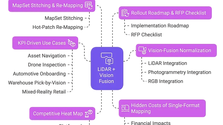
This article unpacks:
Walking the expo floor at any AR conference, you’ll likely see the same glossy demo: a well-lit, open room mapped with a single iPhone. Everything appears perfect - until you exit the booth and enter a real facility. In the real world, a single plant can swing from a dim utility tunnel to a sun-blasted loading bay within fifty steps. One area may need a LiDAR cart due to poor lighting, while another requires a drone because production can’t be shut down long enough for traditional equipment. We’ve lost count of projects that begin with, “One neat scan will suffice,” only to end in a mad dash for additional sensors.
The reality is straightforward: enterprise environments typically require a mix of capture methods shortly after implementation. Why is that?
A logistics operator we know tried to budget around fifty grand to map their flagship warehouse using just phone photogrammetry. Everything went smoothly until they reached the freezer aisles. Metal racks in near-darkness refused to register in the scans, forcing them to rent a LiDAR rover at the last minute. Rental fees, extra software licenses, and overtime to redo the meshes ultimately cost them more than sixty grand on top of the initial fifty. By project completion, their total expenditure was over double the original estimate - solely because their chosen platform couldn’t handle anything that wasn’t a bright, texture-rich JPEG sequence. The lesson? Scan flexibility isn’t a luxury feature; it's the primary factor affecting your true cost of ownership once you leave the showroom and enter the factory floor.
| Input Type | Strength | Weakness | Best Zones | Technical Note |
|---|---|---|---|---|
| LiDAR mapping | Fast capture (1 ha/hour), works in darkness | Noisy edges, large file sizes (2–6 GB raw) | Tunnels, freezer racks | Post-filtering ±2 cm accuracy on commercial scanners |
| Photogrammetry | High texture, low hardware cost (<$2k) | Needs good lighting; risk of drift | Fashion retail, office floors | Feature-based bundler/map pipeline |
| Gaussian Splatting | Fast offline render, small files (<50 MB) | GPU-heavy, limited depth | Pop-up events, showrooms | Multi-plane images fused into “3D billboard” |
| Point-Cloud Anchors | Precise anchor (<3 cm) | Needs GPS or geospatial guess | Museums, city landmarks, kiosks | Upload ≤ 100 MB point set per anchor |
| Pure RGB SLAM | Universal hardware footprint | Fails in glare, darkness, and repetitive textures | Employee ad-hoc mapping | Relies on ORB/FAST keypoints |
A scalable visual positioning system VPS must consider these points as “observation classes” and fuse them.
MultiSet AI’s architecture is designed around three core principles:
An independent audit from the Augmented Reality Enterprise Alliance tested and ranked VPS vendors based on five enterprise KPIs: Environmental Resistance, Indoor Performance, Dynamic Handling, Update Cost, Free-Trial Availability.
| KPI | MultiSet AI Verdict | Summary Verdict |
|---|---|---|
| Environmental resistance | Best | Works under high-lux glare or low-lux basements without extra maps |
| Indoor performance | Best | Centimeter accuracy across a 250 m walk |
| Dynamic environment handling | Better–Best | Responds well to moving forklifts; minor jitter auto-corrected |
| Update cost | Best | Hot-patch tile < 30 MB; devices auto-pulling |
| Free trial | Better | Offers 10 maps for free per user |
Competitor platforms A–C struggled with at least one KPI drop to Fair or Poor. This illustrates the distinction a scan-agnostic core brings.
Most VPS providers say, “Upload your mesh. Wait an hour.” That approach may work unless your mesh hits 4 GB and your freezer area remains unmapped.
MapSet rewrites the playbook:
For a 1.2 million ft² property, a full facility reprocessing typically requires 3–4 hours of GPU time and 80 GB of data transfer. With hot-patching 12 tiles, the requirement drops to 400 MB and < 20 minutes. At $200/hour for GPU time and $0.12/GB for egress, costs decrease from $780 to under $20.
AR deployments can finally find affordability beyond pilot projects.
| Capability | MultiSet AI | Platform A | Platform B | Platform C |
|---|---|---|---|---|
| Scan-agnostic ingest (LiDAR + photo + OBJ) | Best | Poor | Fair | Poor |
| Lighting robustness (glare, < 5 lux) | Best | Good | Fair | Fair |
| Dynamic handling | Better | Good | Fair | Fair |
| Multi-floor stitching | Best | Poor | Poor | Fair |
| Hot-patch tile updates | Best | Fair | Poor | Poor |
Note: Scores reflect public docs, user forums, and Augmented Reality Enterprise Alliance data; they denote relative enterprise fitness, not hobby AR usage.
Here are four real-world stories showcasing how scan-agnostic Vision-Fusion and MapSet hot-patching outperform single-format VPS tools. Click a case that aligns with your environment:
| Must-Have for 2025-2027 | Why It Matters | MultiSet AI | Platforms A-C |
|---|---|---|---|
| True scan agnosticism | Data-prep cost predictability | Yes | Mixed |
| Multi-floor hand-off | Elevators, stairwells, and mezzanines | Yes | Rare |
| Hot-patch re-mapping | No extensive rebuilds required | Yes | Rare |
| Open exports | Digital-twin migrations | Yes | Mixed |
| Free pilot tier | Proof of Concept without procurement | Yes | Rare |
Print it, give vendors a highlighter, and watch them squirm.
Scoping (Day 0)
Pilot Scan (Day 1)
Process & Merge (Days 2–3)
Pioneer Users (Week 1)
Scale-out (Weeks 1-3)
Operationalization (Months 1-3)
AI & Robotics Integration (Quarter 1+)
Vendor-Lock-Out Plan (Whenever)
These differences may seem minor, but they can differentiate between toy-like prototypes and robust, production-ready infrastructures within regulated or critical timing operations.
The AR market’s flashiest demos fall short under freezer-lane darkness or chaotic work environments. The solution isn’t more marketing; it’s a scan-agnostic, drift-resilient, patch-friendly visual positioning system VPS.
MultiSet AI’s Vision-Fusion:
Ready to test without waiting for procurement? The free tier allows you to experiment with 10 maps and 10,000 localizations - a simple way to see how effective AR can be in your operation.