Press Release

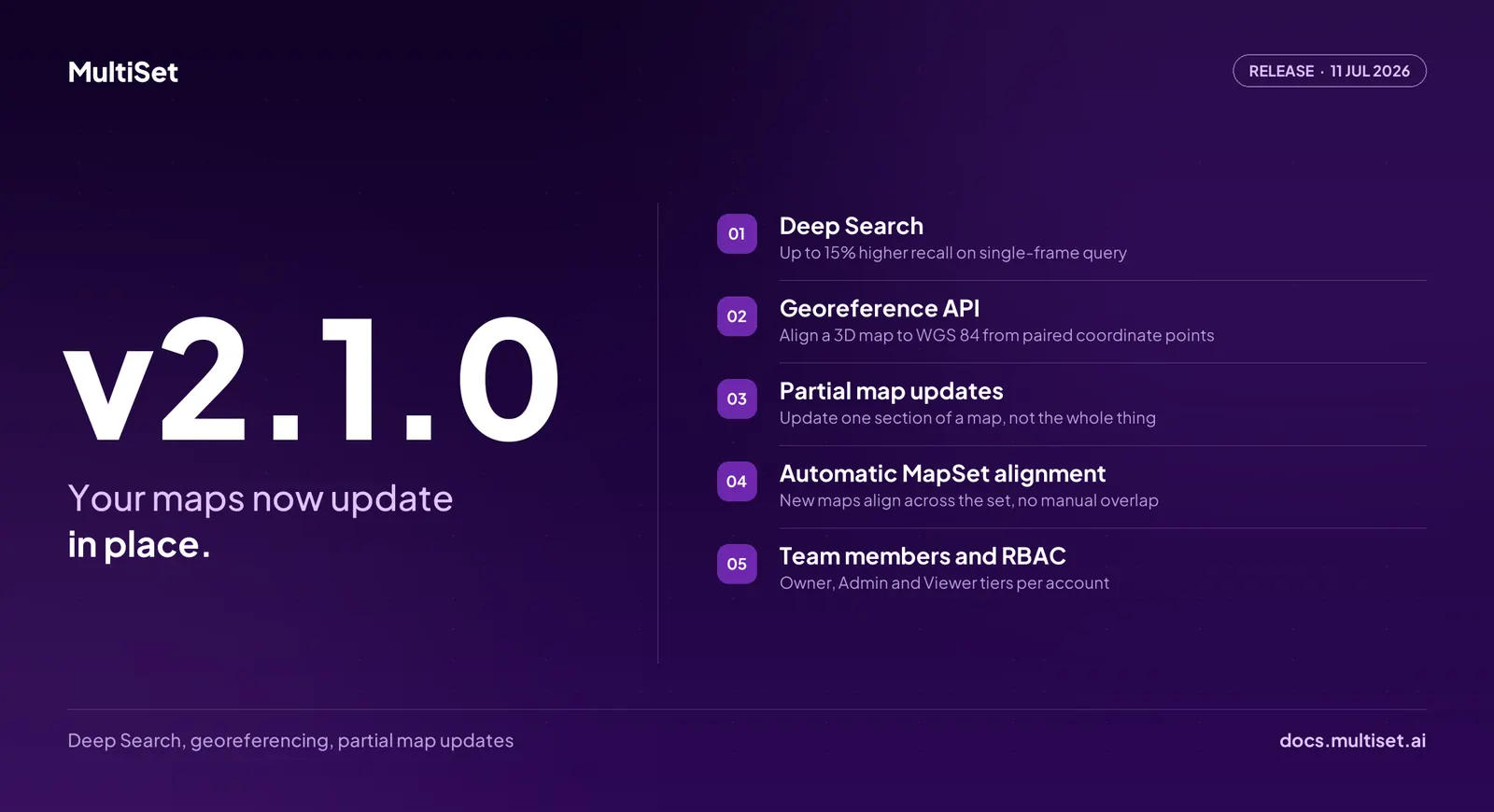
MultiSet AI has released v2.1.0, extending the Visual Positioning System at the layer where production deployments live or die: operations. The release ships four capability shifts at once: Deep Search, a higher-recall localization engine selectable per query; partial map updates, which bring section-level refresh to Map Versioning; a Georeference API that anchors any map to real-world coordinates programmatically; and team roles with access control across every account. Alongside them, MapSet alignment and the 360-to-VPS pipeline both pick up upgrades that reduce the operational cost of mapping large, live environments.
v1.14.0 introduced Map Versioning, treating spatial maps as living infrastructure rather than one-shot captures. v2.1.0 takes the next step: a map version can now hold multiple active maps at once, so operators can push an update to a section of a map instead of replacing the full map.
When one aisle of a distribution center is re-racked or one wing of a hospital is renovated, the team scans that section, adds it to the version, and activates it. Localization queries run against every active map in the version and return a pose in the base map's coordinate frame. Anchors, navigation paths, and AR work instructions authored against the base map stay exactly where they were placed, and no client code changes.
Operators choose which maps participate with the new Query Active toggle in the Developer Portal. The economics follow directly: map maintenance scales with what changed in the space, not with the size of the space. For multi-floor and campus deployments this is the difference between a two-hour section capture and a full-facility re-scan program.
See the Map Versioning docs for the runtime flow and the REST API reference for integration specifics.
The Single Frame Query API now accepts a queryMode parameter that selects the localization engine per request. The default engine, vps-1, is unchanged: roughly 2 seconds per query, built for live AR, in-app navigation, and continuous re-localization. Existing integrations are unaffected; when the parameter is omitted, queries run exactly as before.
The new option, vps-2, runs Deep Search, an engine that searches more of the map before estimating a pose. It delivers up to 15% higher recall and improved accuracy, at a latency of 3 to 4 seconds per query. Deep Search runs at the same rate as the default engine.
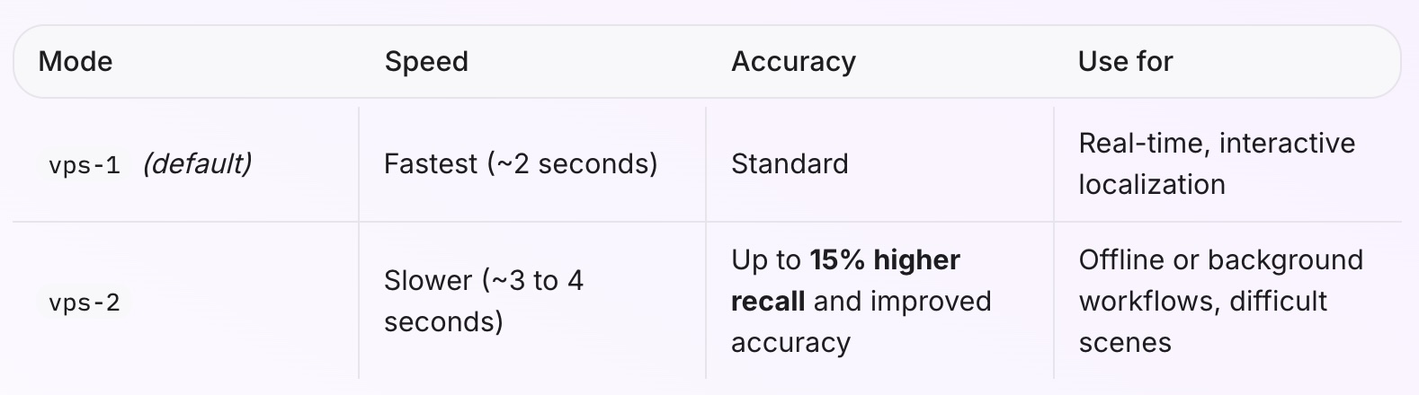
Deep Search earns its latency in the scenes that break single-image localization everywhere: long corridors, basements, warehouses, and transit stations. It also fits workflows where the query is not blocking a user, including background pose verification, offline trajectory reconstruction, and overnight auditing of field captures. A common production pattern: query with vps-1 first, and retry with vps-2 only when the response returns poseFound: false or low confidence, so the extra seconds are spent exactly where they buy a pose.
One point of clarity for teams tracking the platform's engine roadmap: Deep Search is distinct from VPS Gen2. Gen2 is the platform generation that went live in June 2026 and now underpins mapping and localization across MultiSet. Deep Search is a separate, deeper retrieval engine developers opt into per query, on top of whatever a map already runs.
Deep Search is also available in the simulation viewer in the Developer Portal, alongside the existing Single Frame and Multi Frame runs. Teams evaluating the engine can replay their own captured datasets against their own maps and compare recall between engines directly. No site visit, no SDK build: the evaluation runs on the customer's data, not on vendor demo footage.
Full parameter reference in the Query Mode docs.
Georeferencing a MultiSet map, tying its local coordinate frame to real-world WGS84 coordinates, is now an API call.
Developers provide 3 or more control points, each pairing a map-local position with a known latitude, longitude, and altitude. The solver returns the map's origin and heading with no compass reading required, plus the quality metrics needed to trust the fit: horizontal RMSE (the reliable accuracy indicator, since GPS altitude is noisy), per-point residuals, automatic outlier rejection with a 2.5 meter default threshold, and a gravity tilt check. Coordinates supplied at 6 or more decimal places support centimeter-level results, and the call is idempotent: re-running it overwrites the previous solution.
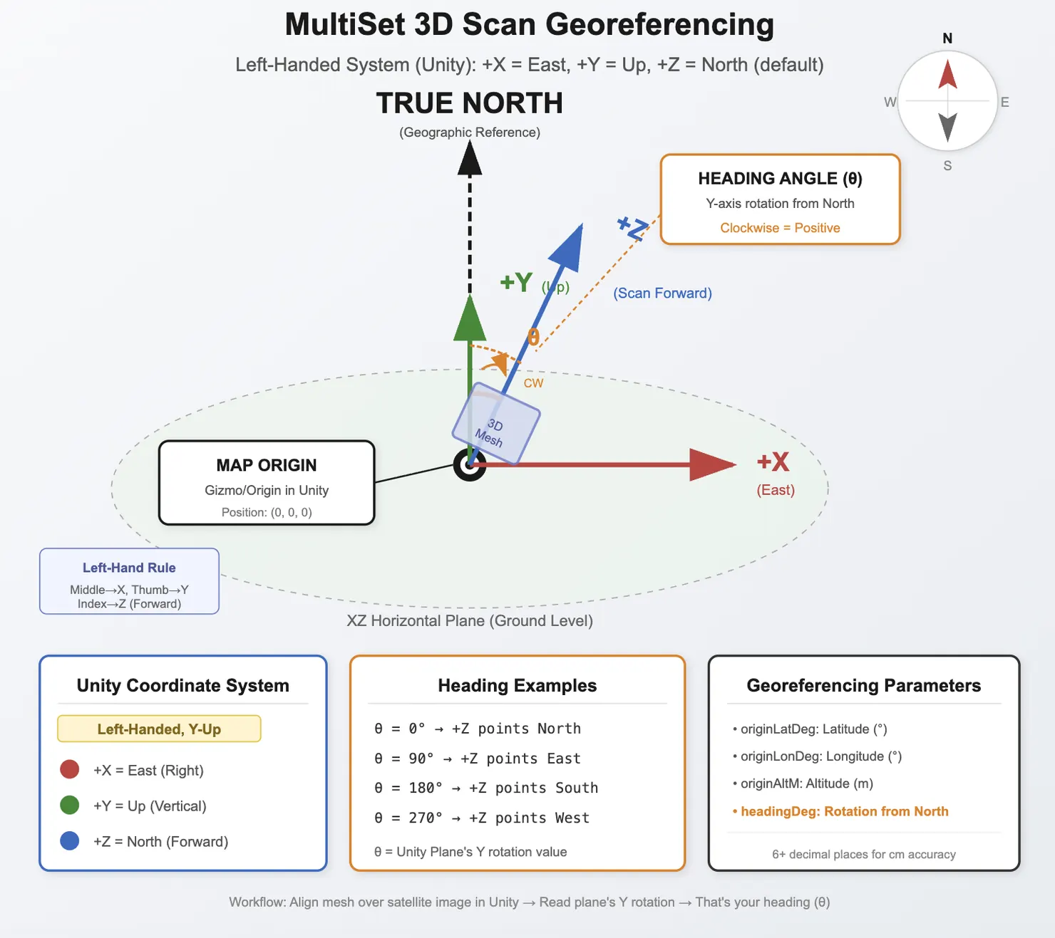
This is the bridge between VPS and GIS. Once a map is georeferenced, localization results can be returned in geographic coordinates, GeoHint can narrow searches by GPS, and every pose a device produces lands in the same coordinate reference that facility drawings, asset registries, and field mapping systems already use. Pipelines that provision maps programmatically can now georeference them programmatically in the same flow, which matters for robotics fleets, outdoor AR, and any deployment where spatial data has to line up with an existing geospatial stack.
Details in the Georeference API docs and the Georeferencing Maps guide.
Three changes reduce friction at venue scale.
MapSet auto-align. Adding a new map to an existing MapSet no longer requires choosing which existing map it overlaps. The new map is aligned against the entire MapSet automatically, and existing maps are not impacted.
GravityAligned merge. MapSet merging now supports a GravityAligned mode, recommended for most merges where maps share the same plane, which covers the majority of single-floor operations.
Moving-object masking in 360-to-VPS. The 360-to-VPS pipeline now masks moving objects such as vehicles and people in the splat, improving metric scaling accuracy. Captures taken during operating hours no longer pay a quality penalty for the forklift or the foot traffic that passed through frame, which makes mapping live facilities, airports, plants, and retail floors during business hours a practical default rather than an exception. Capture workflow details in the Insta360 Scans docs.
Accounts now support multiple members with Owner, Admin, and Viewer roles, enforced across all routes. Owners manage billing and membership. Admins manage content and API credentials. Viewers have read-only access to everything. Invites go out by email, remain valid for 7 days, and members switch between accounts they belong to from the portal's account switcher.
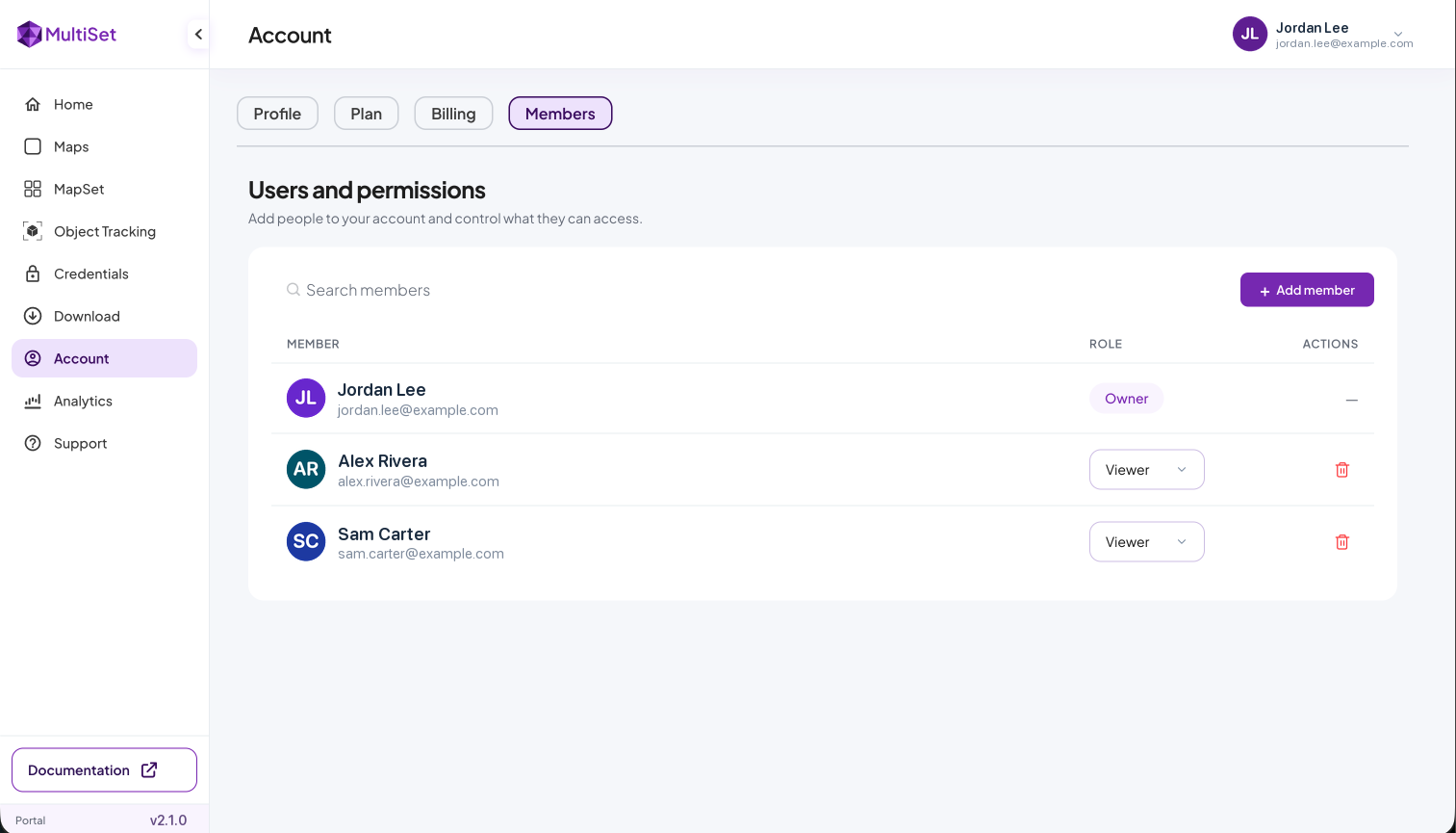
For enterprise buyers, role-based access control is the line item every vendor security review asks about first. It ships in this release, and it composes with MultiSet's existing deployment options across public cloud, private cloud, self-hosted, and on-device.
Setup steps in the Team Members docs.
All v2.1.0 capabilities span the platforms MultiSet supports: Unity, native iOS and Android, WebXR, Meta Quest and the wearable SDK. Partial map updates are fully scan-agnostic, consistent with the rest of the ingestion pipeline: versions in the same group can mix iPhone LiDAR captures with Matterport MatterPak, Leica, NavVis, Faro, XGRIDS, 360 video, and the MultiSet Mapper iOS app, without the content layer ever moving.
v2.1.0 is live now across MultiSet's public cloud deployment and rolling out to private-cloud, self-hosted, and on-device customers on each environment's standard cadence. Existing integrations require no changes: vps-1 remains the default query mode, existing maps continue to work as they are, and partial map updates are opt-in per version. The Developer Portal and REST API docs are updated for the release.